
Buying and Selling
Oceanfront Property on Hawaiʻi Island: What Buyers and Sellers Need to Know
 By Carol Porter, Realtor® · September 4, 2026

An oceanfront home on Hawaiʻi Island can be extraordinary. The ocean view, the sound of the surf, outdoor living, and the feeling of being connected to the coast are part of what makes these properties appealing.
But “oceanfront” is a marketing description, and may not be a complete explanation of a property’s legal or physical relationship to the shoreline.
Before buying or selling coastal property, there are some questions worth answering: Where is the actual shoreline? Where are the property boundaries? What land is included in the ownership? What shoreline setbacks apply? Are there structures or improvements in areas subject to additional regulation? And what does the property’s history tell you about its future?
These questions matter whether you are buying, selling, or simply trying to understand what you own.
Start with the property, not the view
Aerial photographs can make an oceanfront property look straightforward. The house sits near the ocean, the lawn extends toward the water, and there may appear to be nothing between the property and the shoreline.
That doesn’t necessarily tell you what you need to know.
The first step in coastal due diligence is to establish the actual parcel boundaries and understand how the property relates to the shoreline. That means looking beyond the MLS listing and examining the Tax Map Key, recorded documents, surveys, subdivision records, and applicable County and State records.
Hawaiʻi County provides parcel and planning information through its mapping tools, while the State’s shoreline certification process establishes the baseline used to measure shoreline setbacks and helps define the boundary between certain State and County regulatory jurisdictions.
Sometimes that research produces a result that isn’t obvious from the property itself.
Sometimes the apparent shoreline isn’t the property boundary
I encountered a good example while researching an oceanfront subdivision on Hawaiʻi Island.
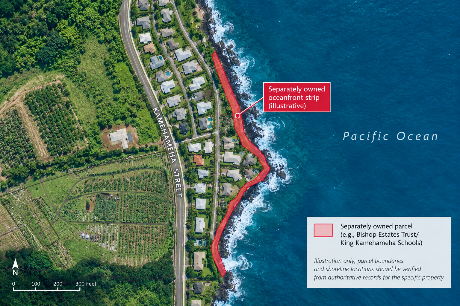
The homes appear to sit directly along the ocean. But parcel research showed that a narrow strip of land between the residential lots and the ocean was separately owned. The strip appeared to be part of the homeowners’ yards, but it was too close to the edge of a 20-foot cliff for practical use. Its ownership mattered to understanding the relationship between the residential parcels and the shoreline.
The subdivision has a history that is not uncommon in Hawaiʻi: the homes were originally built on leasehold land, and the residential interests were later converted to fee simple. The separately owned oceanfront strip remained outside those residential parcels.
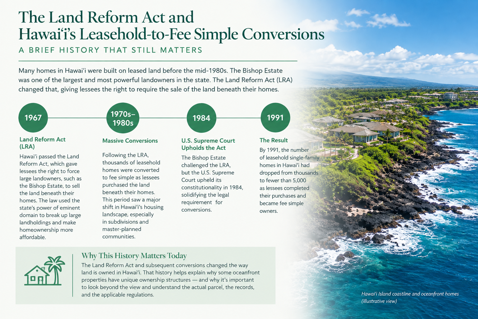
In this case, the parcel research also identified Bishop Estates Trust/Kamehameha Schools as the owner associated with that narrow strip. That makes this more than an interesting title anomaly. It illustrates how the history and structure of land ownership in Hawaiʻi can have practical consequences for homeowners today.
Because the residential parcels did not themselves extend to the shoreline, the homeowners were not in the same regulatory position as owners of parcels that actually abut the shoreline. In particular, they did not face shoreline-certification issues simply because their homes were close to the ocean.
That distinction matters.
When a parcel actually abuts the shoreline, a certified shoreline can become part of the property’s permitting and regulatory picture. The certified shoreline establishes the baseline from which shoreline setbacks are measured and helps establish the jurisdictional boundary between the State Conservation District and the County Special Management Area.
A separately owned strip between the residence and the shoreline can therefore change the regulatory analysis substantially. This does not mean that a property behind such a strip has no coastal regulations or that no shoreline-related review could ever apply. A particular project may still trigger County or State requirements. But the homeowner is not automatically the owner of a shoreline parcel simply because the house is visually oceanfront.
You have to know what you actually own.
What exactly is the shoreline?
“Shoreline” sounds like a simple concept until you are trying to determine where a setback begins.
In Hawaiʻi, a certified shoreline is established through a formal State process. DLNR describes the certified shoreline as the baseline for measuring shoreline setbacks and as an important boundary for coastal regulation and public access.
That is different from simply looking at where the waves happen to be on a particular day.
For a buyer, this can become important when considering an addition, renovation, pool, landscaping, wall, seawall, or other improvement. An existing house tells you what was built. It does not necessarily tell you what can be built, rebuilt, or modified in the future.
That distinction is particularly important with older coastal properties.
The 40-foot shoreline setback is only the beginning
For Hawaiʻi County properties that abut the shoreline, the County states that a minimum 40-foot shoreline setback applies under HRS §205A-43(a) and Planning Department Rule 11-5. Shoreline setbacks are typically established during the permitting process, although not necessarily through SMA review in every case.
That does not mean that every coastal property has a simple 40-foot line on the ground and nothing else to consider.
The actual shoreline, the configuration of the lot, the nature of the coastal area, previous permits, existing structures, and the proposed activity can all matter.
And the setback is not necessarily a measure of how far a property is from coastal hazards. A property can comply with a setback and still warrant careful investigation of erosion, flooding, wave action, storm surge, tsunami exposure, or sea-level-rise exposure.
The Special Management Area adds another layer
Hawaiʻi County’s Special Management Area (SMA) regulations apply to development in the coastal zone. The County evaluates proposed activities in the SMA, and certain activities defined as “development” under HRS Chapter 205A require an SMA Minor or Major Use Permit. A shoreline setback variance is a separate process for situations in which a structure needs to be closer to the shoreline than normally permitted.
I have encountered properties that were within the SMA where the owners appeared to be unaware of the designation. In one situation, the issue surfaced after the sale when the buyer applied for permits for land the buyer believed was available for development.
That experience is one reason I don’t like to answer questions about future improvements to an oceanfront property with a simple “yes” or “no.”
The better question is: What would have to be reviewed and permitted for this particular property and this particular improvement?
That may require looking at the parcel, its zoning and SMA status, prior permits, the shoreline certification, and the proposed project itself.
A cliff can be a shoreline property, too
“Oceanfront” doesn’t necessarily mean “beachfront.”
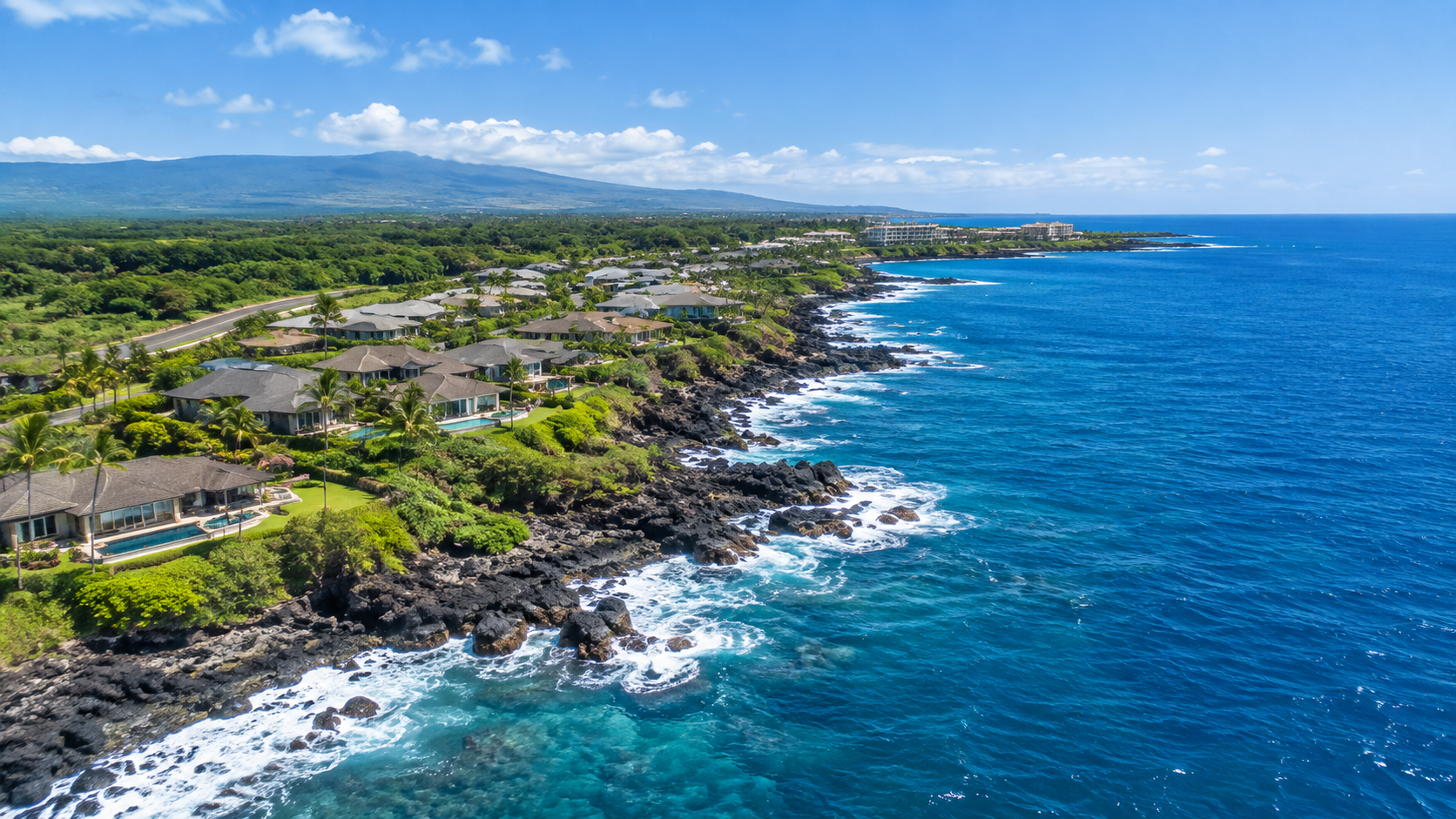
A property overlooking a rocky shoreline or sitting above a coastal cliff can still be a shoreline parcel. The physical characteristics of the coast matter, and a cliff does not automatically eliminate shoreline regulation.
For a buyer, that means the absence of a sandy beach in front of the house isn’t an indication that coastal due diligence is unnecessary.
What about seawalls and other erosion-control structures?
This is an area where buyers and sellers should pay particular attention.
Seawalls, revetments, rock walls, sandbags, concrete structures, and other measures intended to control erosion can involve significant regulatory issues. DLNR treats shoreline erosion control as a regulated land use, and unauthorized structures or encroachments can result in enforcement action.
There is also a specific statutory disclosure requirement for residential property adjacent to the shoreline. Under HRS §508D-15, the seller must disclose permitted and unpermitted erosion-control structures on the parcel, expiration dates of permitted structures, notices of alleged violation, and fines associated with expired permits or unpermitted structures.
This is one area where a seller should not wait until the property is already on the market to start gathering information.
Don’t confuse erosion, flooding, tsunami exposure, and sea-level rise
These are related coastal issues, but they are not the same thing.
A property may need to be evaluated for:
- Coastal erosion — whether the shoreline has been moving landward over time.
- Flooding — including mapped flood hazards and the property’s elevation and drainage.
- Wave and storm impacts — exposure to waves, storm surge, and other coastal forces.
- Tsunami inundation — a different hazard with its own mapping and characteristics.
- Sea-level-rise exposure — the projected effects of rising sea levels over time.
Hawaiʻi law requires certain material-fact disclosures concerning mapped hazards, including sea-level-rise exposure where applicable.
The important point is not to lump all of these into a generic statement that a property is or isn’t “at risk.” The relevant hazards need to be evaluated individually.
Shoreline access is another part of the picture
Owning an oceanfront property does not mean that the owner has exclusive control over everything between the house and the water.
DLNR explains that Hawaiʻi recognizes a public right of transit along the shoreline. Beach transit corridors extend seaward of the shoreline and are considered public property. Coastal landowners also have responsibilities regarding vegetation that interferes with public shoreline access.
This is another reason that understanding the actual shoreline and parcel boundaries matters.
It is also one of the things that makes the example above interesting. The separately owned strip remained between the residential properties and the ocean, creating a physical and ownership arrangement that was quite different from what a casual look at the neighborhood might suggest.
Sellers have homework, too
Most discussions of oceanfront property focus on buyers. Sellers need to do some homework as well.
If you’re preparing to sell a coastal property, I would want to know as much as possible about the property’s history before the listing goes live.
That can include:
- The current parcel boundaries and legal description
- Prior surveys and subdivision maps
- Shoreline certifications, if applicable
- Building permits and records for additions or alterations
- The history and permits for seawalls, rock walls, revetments, or other shoreline structures
- Notices of violation or unresolved permitting issues
- The property’s flood, tsunami, and sea-level-rise designations
- Previous engineering or coastal studies
- Records concerning drainage or water intrusion
- HOA or subdivision documents affecting the shoreline
- Insurance information relevant to the property
- Documentation for significant improvements and systems
- Any unusual ownership or leasehold history
That last item can be particularly important in Hawaiʻi.
Land has changed hands through many different forms of ownership and tenure over the years. A property that appears straightforward today may have a history involving leasehold interests, later fee-simple conversion, separately owned parcels, easements, subdivisions, or other arrangements that aren’t apparent from an aerial photograph.
Preparing an oceanfront property for sale
There is also a practical side to preparing a coastal property for market.
First, make sure you know what you are selling.
If there are old surveys, permits, engineering reports, shoreline certifications, warranties, or other relevant records, locate them before the property goes on the market.
If there is a structure near the shoreline, determine what documentation exists for it rather than assuming that its age means it is grandfathered or that its presence establishes a right to replace it.
If there has been erosion, document what you know. Don’t try to explain away a changing shoreline with landscaping or marketing language.
And if there are shoreline structures or other improvements that could raise questions during buyer due diligence, it is much better to identify those questions early.
The objective isn’t to make an oceanfront property sound less appealing.
It is to make sure the story being presented to a buyer is accurate.
A buyer’s oceanfront due-diligence checklist
If you’re considering an oceanfront or shoreline property on Hawaiʻi Island, here are some of the questions I would want answered.
Property and ownership
- What exactly is included in the parcel?
- Are the apparent boundaries the actual boundaries?
- Is there any separately owned land between the property and the ocean?
- Are there easements, access rights, or other encumbrances affecting the shoreline?
- Does the property have an unusual leasehold or subdivision history?
Shoreline and regulation
- Where is the certified shoreline, if one is required or exists?
- What shoreline setback applies?
- Is the property within the SMA?
- Are there existing shoreline setback variances or other permits?
- What regulations would apply to a proposed addition, reconstruction, pool, wall, or other improvement?
Existing structures
- What permits exist for structures near the shoreline?
- Are there seawalls, revetments, rock walls, or other erosion-control structures?
- Are they permitted?
- Are any permits expired?
- Are there outstanding notices or violations?
Coastal hazards
- What does the property’s history show about erosion?
- What flood zone is it in?
- Is it within a tsunami inundation area?
- Is it within the State’s sea-level-rise exposure area?
- Are there site-specific reports or historical surveys worth reviewing?
Ownership and use
- What shoreline access rights apply?
- Are there HOA or subdivision restrictions?
- Does the property’s ownership history affect any of the above?
Not every property will require every item on this list. The point is to ask the questions that the particular property raises.
The same principle applies to sellers
For sellers, the checklist is slightly different.
Before listing, know:
- What land you actually own
- What structures and improvements are documented
- What shoreline-related permits exist
- Whether there are erosion-control structures
- Whether any permits have expired
- Whether there have been notices or violations
- What coastal hazard information applies
- What unusual ownership or subdivision history may matter
- What documentation you can provide to a buyer
That preparation can make the transaction more straightforward and reduce surprises during due diligence.
The bottom line
Oceanfront property is not simply property with a view of the ocean.
The important questions are more specific:
Where is the property? Where is the shoreline? What land is actually included in the ownership? What regulations apply? What has been built, what was permitted, and what could reasonably be done in the future?
Sometimes the answers are straightforward.
Sometimes, as with the subdivision illustrated above, the ownership history produces an arrangement that isn’t obvious from the street or from an aerial photograph. And sometimes that distinction has a very practical effect on what the homeowner has to deal with from a regulatory standpoint.
That’s why coastal property deserves more than a quick look at the listing.
Oceanfront is a marketing description. The property’s actual relationship to the shoreline is a due-diligence question.
With aloha,
Carol Porter
REALTOR® · RS-87584 · HI · Better Homes and Gardens Real Estate Island Lifestyle
Next step
Questions about your own search?
Every situation is different, and the details change the answer. Tell me what you’re considering and I’ll give you an honest read.